Understanding Political Geography
By Neel Bajaria
Out of the 25 seats in the Hawaiian state senate, Biden managed to win all but one even though Trump won over a third of the vote. On the flip side, Trump managed to sweep all 42 seats in the West Virginia state senate despite Biden earning about 30% of the vote. Even though these lopsided results may suggest that these districts are extraordinarily gerrymandered, even with fair maps, neither Trump, nor Biden, come even close to winning the same proportion of seats as they did votes. The reason: political geography.
Political geography is a concept that describes the distribution of political party strength across a state. It consists of two aspects: the geographical spread and concentration of political party strength. For instance, in most states, Democratic votes tend to come from densely populated cities and inner suburbs while Republican votes come from more dispersed rural and exurban areas. Moreover, many states contain clear gradients of strength around major cities, with heavily Democratic cores that become increasingly Republican moving outwards into rural regions. Seemingly menial, in reality, political geography proves critical in determining the viability and power of the dominant political party by influencing their ability to draw favorable districts. Under winner-takes-all electoral systems, where winning 100% of the vote means the same as winning a single vote, political parties want to design districts that minimize wasted votes, ensuring their voters do not get packed into districts where they win in a landslide. This is where political geography comes in. A favorable distribution of their voters can aid a political party’s attempts to pack and crack their opposition and cement their dominance while disadvantageous features can stymie these efforts. Although strong political geography is a broad and wide-ranging characterization, a party has advantageous political geography if it satisfies one, if not multiple, of the three major categories: even distribution, opposition suffering from extreme concentration, and strong spread.
The first is even distribution, only present in heavily Democratic or Republican states, where a political party’s voters are so evenly spread out across a state that it is simply impossible to draw proportional maps. Minority parties simply fail to win enough precincts to even draw seats that they can win. As mentioned in the introduction, the most prominent Democratic and Republican examples for this are Hawaii and West Virginia, where the Democratic and Republican parties respectively are able to successfully win a majority in urban, suburban, and rural regions. In general, this type of patterning appears in demographically homogeneous states where all regions tend to vote similarly. Other examples of even distribution are Massachusetts and Vermont for Democrats, and Arkansas and the Dakotas for Republicans.

Visual demonstration of even distribution. Although the opposition (red) are expected to win between 1 to 2 seats, because they are so thinly spread out, it allows the majority (blue) to sweep all 6 seats.
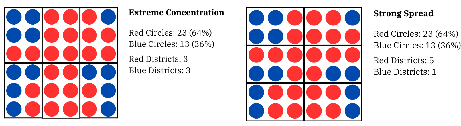
The second is extreme concentration, where voters from a certain party are so heavily concentrated in a region that they naturally gerrymander themselves out of power, often requiring proportional-mandering to remedy this issue. This is most prominently an issue in the Midwest, where significant Democratic strength comes from extraordinarily blue cities, often with significant minority populations. Although Democrats may want these areas to combine with more Republican regions to reduce wasted votes, these districts are protected by the Voting Right Act (VRA). This means that minority communities must have opportunities for representation, mandating that a certain number of majority or plurality minority districts must be drawn to meet these thresholds. Because more Republican regions tend to be whiter, votes from extraordinarily Democratic minority communities cannot be utilized to dilute their votes, forcing Democrats to be packed into 90%+ Democratic districts. Some examples of this poor political geography are Wisconsin, Ohio, Missouri, and Michigan, though this dynamic is taken to the extreme particularly for the former two states. However, that doesn’t mean that this issue doesn’t affect Republicans. While they tend to have advantageous political geography in general, by virtue of cities being bluer and more concentrated than their surrounding rural areas, there are states where Republicans are actually the ones concentrated in heavily Republican areas while Democrats are well spread out. Two prominent examples would be Nevada and Alaska, though for opposing regions. In Nevada, Republicans are concentrated in extraordinarily Republican, high-turnout rural areas, allowing Republican voters to naturally pack themselves into districts with significant amounts of redundant votes. In contrast, in Alaska, Republicans are concentrated in heavily Republican and urban oil-producing regions of the state while Democrats dominate the rural Native Alaskan vote, an inverse of typical patterns in the continental US.

Visual demonstration of extreme concentration. Although the majority (blue) is expected to win between 3 to 4 seats, because their political strength is so concentrated into a corner, it allows the opposition (red) to win 4 seats instead.
The last one is strong spread, a unique category that combines aspects of even distribution and extreme concentration of opposition. Although the dominant political party isn’t evenly distributed, the pockets where they are dominant are spread out well. While this category can be murky, there are some clear examples. For instance, in New Jersey, although there are Democratic and Republican areas, unlike states where Democratic strength is concentrated in a corner, Democratic cities follow the I-95, which cuts straight through the center of the state. Republican-leaning regions can more easily be folded in with Democratic-leaning cities. Conversely, in Utah, while its capital is a Democratic stronghold, because Republican-leaning regions completely surround it, any Democratic strength can be easily diluted away. In both examples, while there were Democratic and Republican-leaning regions, the placement of the dominant party’s political strength allowed for an efficient and seemingly natural dilution of the opposing party’s voters.

Visual demonstration of strong spread. Although there are areas where red appears dominant and areas where blue appears strong, the region of blue dominance cuts diagonally across the map and allows for the potential to dilute red areas. Although the majority (blue) is expected to win between 3 to 4 seats, because of their strong spread, they are able to win 5 seats while opposition (red) is confined to 1.
Although most states generally fall into one of the categories, one major exception is the South. Because of racially polarized voting patterns and its long history of segregation and redlining, communities in the South often deliver landslide results for either party, with Democrats dominating majority-Black areas and Republicans winning majority-White areas. For instance, in many counties in the U.S., an R+20 county will be evenly Republican throughout. However, in the South, an R+20 county can be evenly split into a D+30 section and R+70 section. This extreme concentration of Democratic and, in particular, Republican votes means that it is theoretically possible to gerrymander Democratic districts to allow Democrats win a majority of seats in places like Louisiana or Mississippi. No where else in the US can Republicans be packed into 80%+ Republican seats. However, there is a catch: Republicans have a strong spread in the South. Republican voting areas are located close to Democratic voting areas, allowing Democratic votes to be diluted away. It’s especially brutal due to inelastic voting patterns. Thus, while the South’s political geography is theoretically beneficial for Democrats, in practice, Republicans’ strong spread nullifies this advantage.
Visual demonstration of the extreme concentration vs strong spread dynamics of the South. Because of extreme concentration in the majority, despite being expected to win 4 seats, the red circles only are able to win 3. However, because the majority (red) is spread out well, with a different district configuration, they win a comfortable 5 seats, punching above expectations. Entrenched political advantages allow the majority to opt for the map on the right, even though the extreme concentration could theoretically benefit the opposition (blue).
Understanding a state’s political geography is important because it governs the potential and extent to which parties can gerrymander maps in their favor. In states where the dominant party has poor political geography, gerrymandering efforts can be stymied or made particularly awkward. In Oregon, for instance, because Democratic votes are heavily concentrated around Portland, located near a corner on the state’s border, gerrymandering becomes quite awkward, with multiple districts snaking towards Portland. For Republicans, Texas is a prime example, with Republicans forced to create snakey districts to combine rural regions with rapidly left-trending suburbs and cities and avoid 80+% rural Republican districts. Even outside of gerrymandering, strong political geography plays a critical role in tilting fairly or independently drawn maps towards certain parties. In places like the Midwest, the tipping point seat in fair maps is often two to three points right of the state as a whole, while in other places, like Alaska or Nevada, the tipping point seat in fair maps can be double digits to the left of the state.
Given how political geography can compound advantages and tilt elections towards parties purely based on how their voters are distributed, the major question then becomes: are there ways to circumvent the impacts of political geography? The simplest answer would be proportional representation, where parties win seats based on the proportion of votes they earn rather than if they had earned the majority. Suddenly, winning with 100% of the vote and winning by a single vote matters significantly, meaning that there are no wasted votes–everyone’s vote matters if parties are aiming to hit as high a percentage of the vote as possible. Although it may be saddening to see Democrats lose large numbers of seats in places where political geography had benefited them, proportional representation would produce a lifeline for struggling Democratic parties and voters in heavily Republican states, finally allowing their votes to be heard.
Featured Image: Brilliant Maps